|
|
|
|
Well log interpolation guided by geologic distance |
Next: Numerical examples Up: Method Previous: Predictive painting
|
|
|
|
Well log interpolation guided by geologic distance |
 , whose value decays along the increasing distance (Micchelli, 1984).
An inverse quadratic form of the RBF is:
, whose value decays along the increasing distance (Micchelli, 1984).
An inverse quadratic form of the RBF is:
 (2)
(2)
Then the interpolation can be calculated as below:
 (3)
(3)
 is the result of spreading well log at well location
  into the seismic data and
  represents the total number of used wells.
We propose to extend the definition of  from simply the horizontal distance
 to the geologic distance that is measured along the seismic horizon:
 (4)
(4)
 ,
,  are points along a seismic horizon
 ;
;
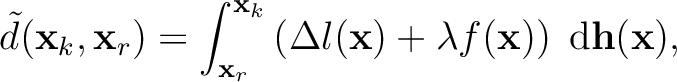
 is the curve length of the horizon, it can be calculated by
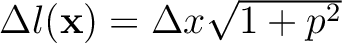 given local slope estimation
  ;
;  is fault attribute and
  represents the distance penalty parameter, this term exaggerates the distance across fault.
The geologic distance indicates the decay of information confidence from the reference trace.
We perform this integration efficiently by accumulative predictive painting.
represents the distance penalty parameter, this term exaggerates the distance across fault.
The geologic distance indicates the decay of information confidence from the reference trace.
We perform this integration efficiently by accumulative predictive painting.
|
|
|
|
Well log interpolation guided by geologic distance |